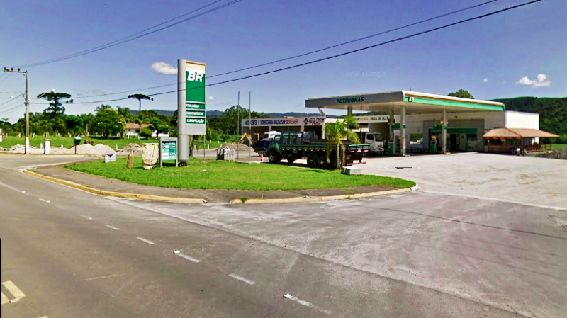
 THE FUEL STATION had been a rejuvenating haven for the last hour. My mind had been on the fuel gauge nudging empty most of the way climbing out of Braço do Norte toward Serra do Corvo Branco, which took a little shine out of the experience.
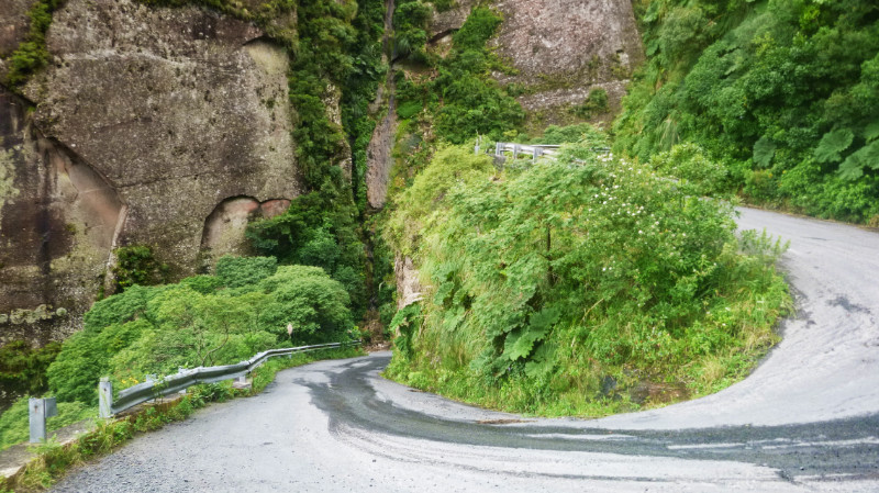 Riding over the Serra had been a real treat and I failed to get the best photographs of it by not knowing the relatively short length of the pass. By the time I’d got my GoPro out it was nearly over and I caught the last hairpin before reaching the crest. It reminded me of El Camino de la Muerte in Bolivia although that was almost 60km long. This was what, maybe 6…?
 Almost mid-afternoon. Too early to retire to a hostel. A huge chunk of day waits to be carved out of the bright Santa Catarina afternoon. Maps.me shows a selection of about eight waterfalls clustered on its map not far northeast of Urubici, most of the route planners return “inaccessible” so I embark on an expedition to the most ‘accessible’ looking waterfall on the app… and perhaps I won’t need a hostel if I pitch my tent there. After all, 28km isn’t far and shouldn’t take long.
Bike and body fully refuelled and refreshed, I memorise the next few junctions of the route and accelerate out of the fuels station to retrace the last half mile to the junction for the trail toward this imagined Eden.
A pale dusty trail between fields to a right hand dogleg that tracks me along the Rio Canoas and a left-hand bend to a wooden bridge from which children are laughing and jumping into the river, entertained by the pequeno Yamaha from Peru rattling over the loose planks.
The next way point? A sharp right away from the river and second right junction with a bend to the left to reach the next bridge across another river. I remembered the route well but the scenery never matches my imagination.
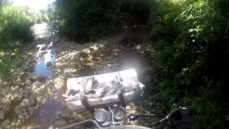
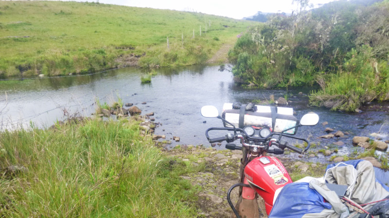
 The road degrades into what looks like farm access and down a stony dirt slope then smooth large pebbles descending to the river. The trail leading into the water suggests a ford but there appears to be no exit on the other bank.
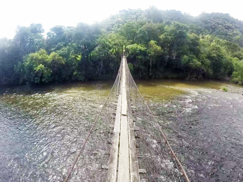
 Checking Maps.me and zooming in, my marker is off the route. The bridge should be 20 or 30 metres back. I abandon the bike and clamber up the stony lane. There is indeed a bridge but it’s through a narrow gate to a rickety suspension footbridge less than a metre wide. Even if it were wide enough for a motorcycle, the wire structure looked incapable of enduring our combined weight. Maps.me showed this as a drivable route.
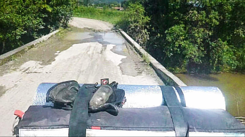
 Zooming out on the app, I notice another crossing not far further north. Backtracking past the farmhouses of imagined occupants looking out of the window bemused by foreign traffic along this almost impassible route, I reach the t-junction, turn right along the narrow lane and squeeze past trucks loading crates of fruit harvested from the neighbouring fields and soon cross bridge number two on the GPS: a concrete single width structure of little beauty but herculean looking strength, starkly contrasting the spindly footbridge upstream.
 The dry pale track slowly morphs from dusty to alternately rocky and grassy. The further I travel, the less evidence there appears of recent traffic. Maps.me reassuringly puts my location firmly over the projected route. I’m still on track all right, so give a mental shrug and carry on, powering up the rocky inclines crouching on the pegs to allow the bike to bounce over the rough terrain without my torso adding to the inertia.
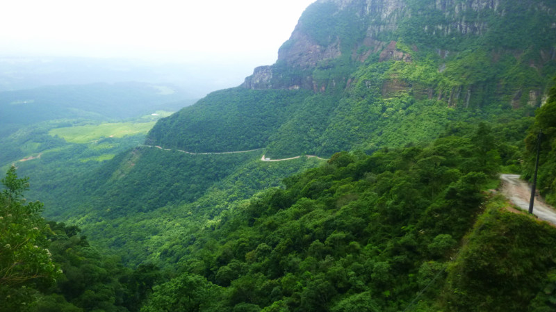
The route climbs steadily into the hills in and out of woodland Drinking in the clean Brazilian air, laced with aromas of pine and eucalyptus, I’m rewarded to panoramic views over the emerald green Santa Catarina landscape bathed in golden sunlight.
Further and higher, the lane terminates at a gate to a field. In the distance, I spot an off-road motorcycle bounce its way over a ridge and disappear leaving only the sound of its engine fading into the distance and decide to follow. That was the last I saw of it but the GPS still pinned me firmly tracking its route. Distant cows and horses turn their heads as my wheels join up the vague and intermittent wheel tracks across their undulating green pasture from one gate to the next.
These gates are typical barbed wire and post affairs held taught by a loop of wire top and bottom of the gatepost. Some take a lot of grunting to get that last 2mm of wire to slip over the top of the post but are more an annoyance than a problem: dismount, drop gate, push bike through, grunt wire loop back on post, re-mount, repeat at next field.
The trail disappears again and I stop in the middle of green pasture and inspect the map. Nearly two hours of rugged torture over rocky slopes tempts me to abandon the expedition but, according to the app, my holy grail is now only 6km away. Eighty per cent there…
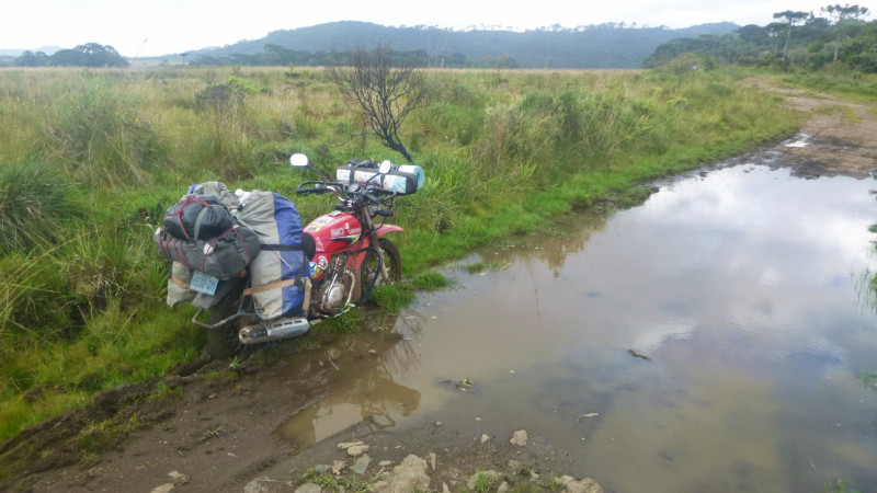
Guessing the path of least resistance over the pasture takes me over a grassy ridge to pick up defined wheel tracks again. The tyre tracks become more pronounced and disappear into a wide puddle through boggy ground. This vague trench seems to reveal itself by longer grass than the rest of the field as it traverses its way each side of the track in a tentative ambition to perhaps one day become a river. The water in the wheel tracks obscures its depth and the nature of the underlying ground and I try to follow the shallow edge before I’m hub deep in peaty mud.
 Maybe this is a clue that I should turn back but quitting after coming 80% distant doesn’t really inspire. No need to put the stand down, the bike remains upright as I dismount and squelch the few paces back to firm ground and take a photo.
Staring at the bike, I rue the prospect of untying those bags and then reloading so I kick the gears into neutral and heave on the bar that crosses the back wheel bracing the two sides of the luggage rack. With enough grunting and desperation of avoiding unloading the bike, it begins to move and I stagger back until it topples over to the right releasing the wheels from the mire and I fall back into half dry ruts.
Washing my hands and boots a little in the muddy puddle, I remount the bike and commit myself to a watery wheel track with enough speed to either plant me firmly in the centre of the bog, if that is my fate, or to hurtle out the other side and along the track toward whatever further obstacle awaits. Beneath the surface, the bed is firm and shallow and I cross the water smoothly without drama.
The pasture and scenery become like Exmoor back in the UK, scrubby bushes and short grass. The trail dips into boggy ground again but I notice faint wheel tracks veering away over the short grass over a ridge behind some bushes I follow those over a crest to rejoin the trail thirty metres further on. I enjoy a pleasant sensation from the minor victory of bypassing another hazard.
Random buildings in fields reinforce the feeling I’ve strayed into someone’s farm. And I continue checking the GPS for reassurance.
The trail has been rough and rocky most of the way, testing my off-road skills to the limit. The Yamaha doesn’t have low enough gearing to maintain torque and revs at low speed so I have to commit to maintaining momentum over punishing terrain if I am to make it up these inclines at all. It’s a wonder the bike holds together at all with the weight of the baggage strapped across it. And how does Maps.me know about this route as it’s barely recognisable as a trail in reality?
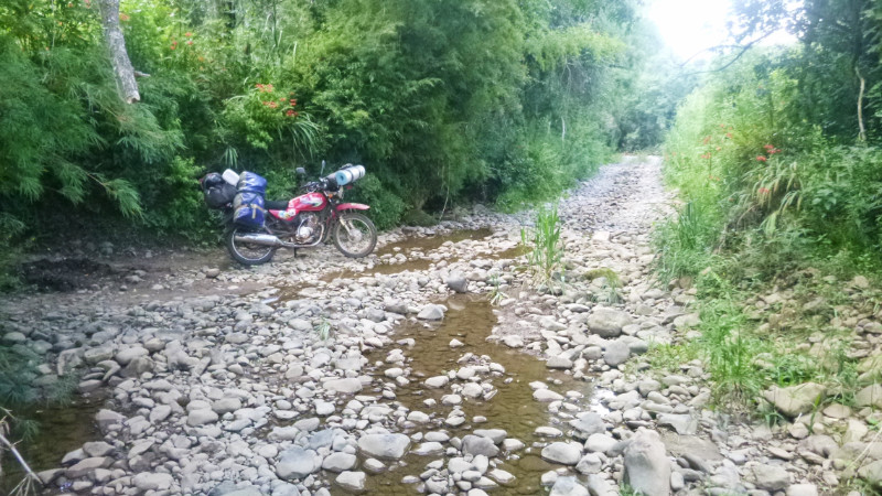
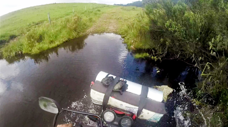
 The trail disappears into yet more water. This time, a bonafide ford, a narrow stream but with a stony bed. I don’t know how deep it is but I can see mango-sized pebbles in the shallows before the reflection of the sky on the water obscures the view halfway across. It looks harmless enough though. It’s not wide enough to be deep and also a ford.
 I hesitate and consider turning around but the GPS tells me my destination is now only 2km away. So close! I have hammered out 26km of rocky trail already, more than ninety per cent distance. If I can make the last 2km then I can pitch the tent and watch the sun go down from the hammock and maybe bathe in the crystal waters of the waterfall.
I spare a thought for the laptop and chargers in the bags but reassure myself that they are packed near the top of the bags and all it takes to cross is a little confidence and I’ll be through with no problem.
The bed of the stream proves rough but firm and I rattle across toward the far bank before the front wheel suddenly lurches to one side wedging itself between two boulders and I plunge my feet into the water to stop the bike from tipping over. The water is halfway up my calf and I keep the revs up unsure whether the bike’s exhaust is underwater or not. Now upright, I slowly dismount and, under its own power, walk the bike out of the stream feeling relieved that I didn’t drop the whole thing.
I’m clear of the stream and back on dry land wet trousers clinging to my calves and boots brim-full of water. I remount and continue to the next gate perhaps 200 metres away and gaze across another green, blank field. The trail clearly passes through this gate but after that, I see no evidence of its path across the grass. Horses pause their grazing to stare at me as if to ask me “What now?” A farmhouse perched on the far side of the field hints at a descent into the valley beyond where must surely nestle the elusive paradise of the waterfall.
I put my hand in my pocket to retrieve the phone and check the route on the GPS, only to find heart-stopping emptiness. I check my other pockets. No phone. Well, it couldn’t be far away since I’d checked this unbelievable route before the ford. The prime suspect was the site of the wrestling match to keep the bike falling into the water and I race back to the ford hoping to catch a glimpse of the phone on the grass.
In the murky black depths of the stream, spotting a black smartphone is impossible, but not so the coil of the white USB cable still connected to it… exactly the spot where the bike wedged itself between the boulders. I rolled up my sleeve and waded in to fish it out hoping for the best. Unplugging the USB cable prompted the screen to display “Powering Down” as if this was its dying breath, the last time I ever saw it alive… RIP GPS… RIP: Internet, Translator, Whatsapp, Kindle, Camera, Clock, Banking Authentication. Goodbye connection to the wider world…
Well what now…, 2km from my imagined paradise past a suspected farmhouse assumed to be near an undefined trail to an unconfirmed waterfall with no aid for navigation or communication? The nature of my journey had changed from one of spiritual reward to one of material loss. That feeling of loss put me out of the mood to continue altogether.
That’s it. This was enough adventure for one day…
It could be worse. The sun was still high in the sky and I still had 2 or 3 hours daylight. All I had to do was retrace the 26km back to the main road and maybe find the Morro I’d seen signposted earlier off the 370, when I was looking for a fuel station, and camp there.
Would I remember the way? It only takes one wrong turn. Yes, it was a concern but the other thought was, “So what? If it gets dark pitch your tent. No-one is coming here tonight.” Apart from one remote motorcycle and some farm trucks loading crops down in the valley I hadn’t seen any other traffic. So what? It doesn’t matter. It was only uncertainty that was causing the discomfort.
Stashing my waterlogged phone, pouring the water out of my boots and wringing out my socks, I check over the bike and prepare to rejoin civilisation. I choose the alternative wheel track across the ford to find it far smoother and cross easily without incident. Small waves of relief and regret ebbed then flowed on the shore of my consciousness. Relief that I crossed, this time, without effort and regret that this wasn’t the wheel track I’d chosen in the first place.
I move faster now, knowing the nature of the terrain ahead, gravity on my side, relying on brakes to regulate momentum rather than power, standing on the footpegs to allow the bike to move beneath me. I look for forks in the trail across the fields bypass the bogs and I plough through soft ground fast enough to cut through and reach the other side before the mud can grab my wheels.
Yet another fork in the track leads left toward a defined trail and right to an equally defined trail. I’m not certain but I take the one to the right only because I see a gate further on that has the trail continue through to the other side. It’s fifty-fifty. Time will tell.
I check the odometer for progress and notice the speedo and odometer are no longer working. Great, no GPS plus now no facility for measuring distance or speed. Even time had been measured using the phone.
I would just have to estimate time and direction by the sun and estimate distance by a function of estimated time against estimated momentum: not much better than a guess.
The sun was low enough in the sky to point the way west and high enough that I still had a couple of hours of daylight. A hand’s width on an outstretched arm between horizon and the sun equates to about an hour and one finger width to about fifteen minutes. Wisps of misty cloud shrouding these hilltops threaten fog to obscure the sun adding to the Exmoor-like experience but thankfully begins to thin out at the lower altitudes and are soon behind me.
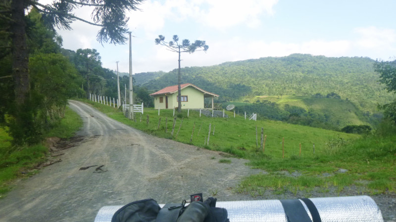 Fairly soon, I arrive at a landmark I remember, a house at a junction that I had stopped to photograph on the way. The reassurance boosts my morale and I press on down the trail.
Thighs burning from the extended crouching position riding over rough ground, I slowed a little so I could sit down over the not so rough terrain.
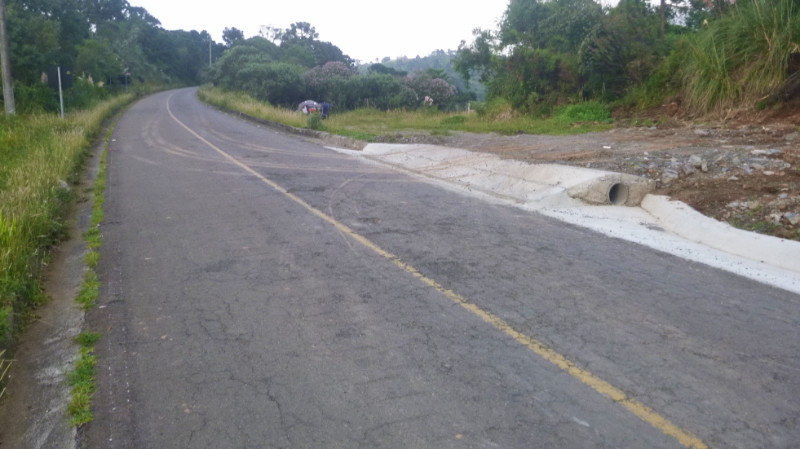
The trail gradually smooths out and my tyres are eventually whipping up the chalky dust between the fields at the valley floor. Pausing at an unfamiliar junction, engine burbling calmly in neutral, there’s a river on my right that should be on my left. I had already passed a turning across a bridge so that must have been the one I’d originally crossed. Doubling back the 200m I’m back on the familiar route where the trucks had been loading, the fruit trucks had now gone and the descending sun paints the dark shadows of the trees over the track and into the fields. Passing the junction leading to the suspension bridge then onto the riverside and rattling over the planks of the wooden bridge echoing the laughter of the absent children, I reach the silky smooth asphalt of the SC370 and pause at the junction to savour the warm satisfaction of my return to civilisation. “The Eagle has landed…” Not that it felt like I had been to the moon and back but that my adventure had been lost in the space of persistent uncertainty…
Turning left I estimated the Morro I had seen was maybe 10km away, maybe 15… I had no odometer anyway so I’d guess for 15 minutes with the rev counter at 6000 in top gear, as the phone’s death left me no clock and the speedometer needle was dormant at zero.
The sun was still above the horizon, barely. The return trip from the ill-fated waterfall excursion had been a lot quicker than the outward leg.. It was downhill for a start, plus I didn’t have to keep stopping to check the GPS since I no longer had one.
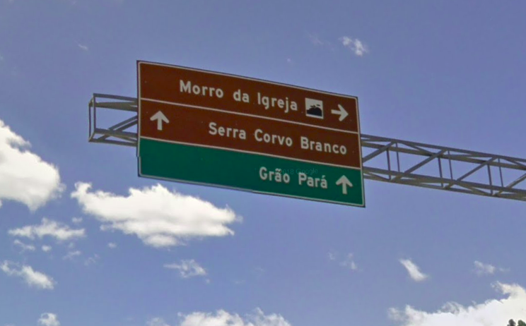 About 15 minutes along the SC370, the sign to “Morro de Igreja” and followed it right, south along the road that zigzagged up the mountain, past construction crews resurfacing it, and through the low cloud base in and out of grey mist. It was late enough now that I already had my eyes open for “Plan B” camping sites. Spindly woods along a dubious looking lane was one, a green area in front of a farm gate was another until I finally reached the site that iOverlander indicated had a waterfall with a restaurant that allowed its reviewer to camp there.
Turning into the entrance and down the drive, a girl wearing black leggings, trainers and earphones was marching toward the road with purpose and I said Hola rolling on by, eager to pitch camp.
I coasted in past a booth displaying a “Fechado” sign and was met by a man emphasising “No, closed. Come back tomorrow.” He summoned his son who could speak a little English. He told me “No, closed, come back tomorrow.” I asked about somewhere to camp hoping he would say, “How about here on our ample grounds” but no, he said somewhere on the main road near a hump. “My sister speaks good English but she’s just gone for a walk”
I exited demoralised and passed the girl now at the road without bothering to stop to speak other than say “Tchau.” as I rode toward my “Plan B”.
Dusk was upon me and I was starting to feel cold. Checking out the dubious lane with spindly woods didn’t inspire confidence. I felt I’d be trespassing on a family estate if there is such a thing in Brazil. I continued down the road to the farm gate.
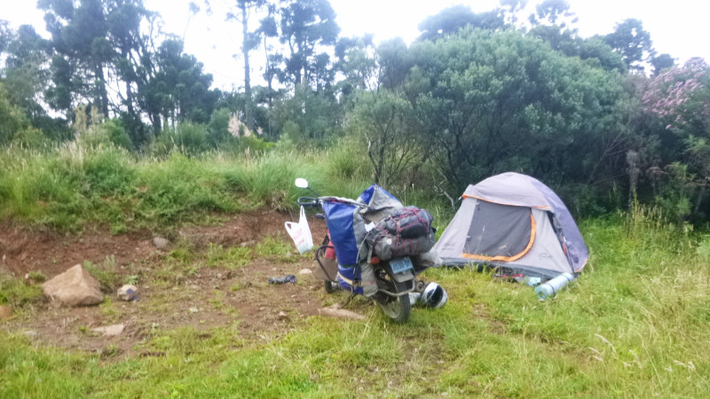
 There was nothing but a field entrance here. Visible from the road, being right next to it, wasn’t ideal but there was very little traffic. It was time. The sun had set, I was cold and tired. I pitched the tent in the rough grass, flattening the groundsheet over the springy weeds best I could, stripped the insoles out of my boots and draped my socks to dry over the handlebars of the bike.
 My cold, white feet looked like dead fish due to their few hours of marinating in soaking boots. No phone, a broken speedometer, wet boots. The whole excursion to the waterfall had been a disaster but thinking about it, I was both amazed and grateful that the bike didn’t break its back over the terrain.
And wow, what an adventure, now that it was all over and its memory cemented into the certainty of the past…
Adventure and uncertainty: seems one doesn’t exist without the other…
This is the archive. Everything here stays free.
The ongoing experiment — what's actually happening now — is at Substack. If you want to follow it in real time, that's where to go.
lifewithglee.substack.com →


Wow! Eventful outing, but the places you described were beautiful enough to make an impression & enter into your story so we’re well worth experiencing/seeing